글
[CNN 동영상/태풍 볼라벤] Massive Typhoon Bolaven slams Okinawa, heads for Koreas
Tokyo (CNN) -- A massive typhoon crossed over Okinawa on Sunday, bringing winds more ferocious than even the typhoon-weary Japanese island has seen in decades.
Typhoon Bolaven, with wind gusts that reached as high as 259 kilometers per hour (161 mph), is the strongest to strike the region in nearly 50 years. And with a cloud field of 2,000 kilometers (1,250 miles), it is 20 times larger than Okinawa's length.
"It's been very, very severe," said storm chaser James Reynolds, who was on the northwestern coast of the island during the worst of the storm.
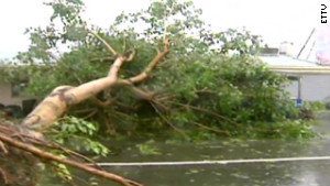
Tree branches were flying through the air amid torrential rain, he said.
Speaking to CNN early Monday morning on Okinawa, Reynolds said, "It's been a long and rough night."
"The eye of the typhoon actually crashed ashore just after dark. ... Like the rest of the population we all just kind of holed up in the strong and sturdy buildings which make up Okinawa," he said.
The infrastructure on Okinawa is designed to withstand violent storms. "Everything's made of solid concrete," said Reynolds.
The last storm of this scale was Typhoon Naha in 1956.
At 3 a.m. Monday local time (2 p.m. ET Sunday), Bolaven had winds of 194 kilometers per hour, with gusts at 240 kilometers per hour, CNN International meteorologist Jennifer Delgado reported.
Bolaven could make landfall at the Korean peninsula on Tuesday morning, or potentially in South Korea on Monday night, Delgado said.
Isaac near hurricane strength; watch extends to Louisiana
In the meantime, rainfall totals in Okinawa could top 500 mm (20 inches) in 24 hours, said CNN International meteorologist Tom Sater.
Bolaven is "roughly the size of France to Poland in land mass," said Sater.
Time: Most destructive U.S. hurricanes
Storm surges were expected to be a major problem for Okinawa. More than 400,000 people in the area live at elevations less than 50 meters (164 feet).
"The large battering waves on both sides of Okinawa are going to be a threat to people living near the water," Reynolds predicted. "But I think the worst has passed now. The storm is moving away and unfortunately it's the people in the Korean peninsula who look like they've got to prepare for the incoming storm."
Taiwan, meanwhile, could be in for a pounding due to something called the Fujiwhara effect.
Typhoon Tembin made landfall in southern Taiwan a few days ago, and was expected to work its way toward Hong Kong. But Bolaven, which is much stronger, has stopped Tembin's movement toward Hong Kong and has been spinning it around. Tembin is likely to make a second landfall in southern Taiwan, also on Tuesday morning.
"As Typhoon Bolaven moves northward towards the Yellow Sea, it will drag Tembin toward the China coast very near Shanghai," said Sater. "That's an amazing change in direction."


